
| Contents | ||
| Executive Director's Foreward | ||
| Executive Summary | ||
| 1 | Introduction | |
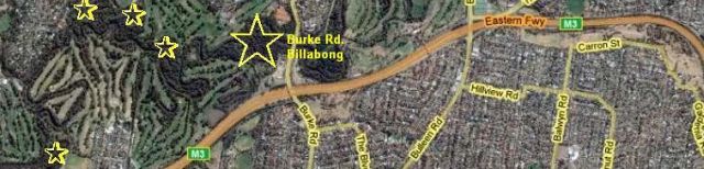
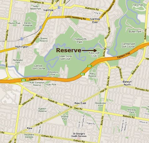
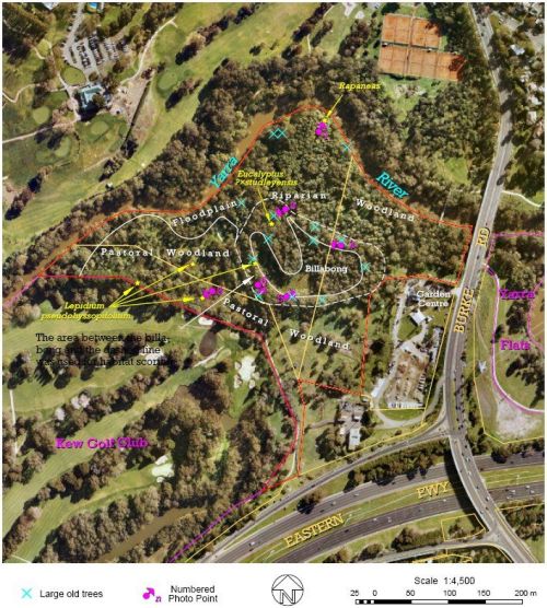
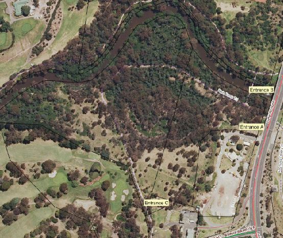
| 1.1 | The Reserve | |
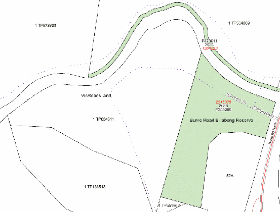
| 1.2 | Land status | |
| 1.3 | Management responsibility | |
| 1.4 | Relevant legislation | |
| 1.5 | Adjoining land | |
| 1.6 | Stakeholders | |
| 2 | Existing conditions | |
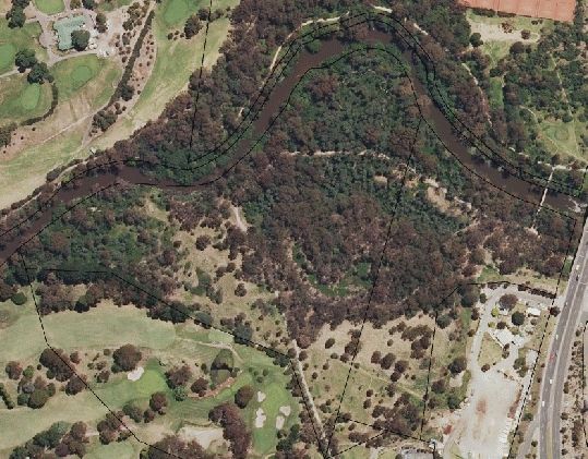
| 2.1 | Aerial photo | |
| 2.2 | Climate | |
| 2.3 | Geology | |
| 2.4 | Soil types | |
| 2.5 | Hydrology | |
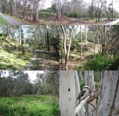
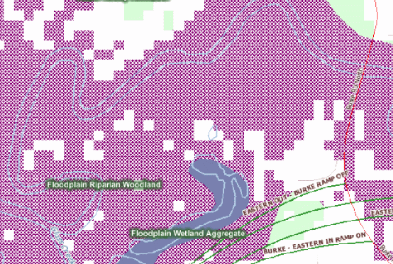
| 2.6 | Vegetation | |
| 2.7 | Animals | |
| 2.8 | Infrastructure | |
| 2.9 | Current use of the reserve | |
| 3 | Issues | |
| 3.1 | Strengths | |
| 3.2 | Weaknesses | |
| 3.3 | Opportunities | |
| 3.4 | Threats | |
| 4 | Future directions | |
| 4.1 | Objectives | |
| 4.2 | Principles and approach | |
| 4.3 | Imperatives and priorities | |
| 4.4 | Vegetation | |
| 4.5 | Billabong management | |
| 4.6 | Animal management | |
| 4.7 | Access: facilitation and control | |
| 4.8 | Education | |
| 4.9 | Recreation capabilities | |
| 4.10 | Pollution | |
| 5 | Implementation | |
| 5.1 | Priority management actions | |
| 5.2 | Work priorities 2010-2011 | |
| 5.3 | Where and When | |
| 6 | Review requirements | |
| 7 | References |
| Mammals | Birds | Fish |
| Black rat Rattus rattus | Spotted turtle-dove Streptopelia chinensis | European carp Cyprinus carpio |
| Red fox Vulpes vulpes | Common blackbird Turdus merula | Redfin Perca fluviatilis |
| Common Name | Scientific Name | Priority | Weed of Nat. Significance |
| African boxthorn | Lycium ferocissimum | High | No |
| Bitou bush | Chrysanthemoides monilifera | High | Yes |
| Black bindweed | Fallopia convolvulus | Moderate | No |
| Blackberry | Rubus fruticosus agg. | Moderate | Yes |
| Boneseed | Chrysanthemoides monilifera ssp monilifera | High | Yes |
| Box elder | Acer negundo | Moderate | No |
| Chilean needle grass | Nasella neesiana. | High | Yes |
| Cleavers | Galium aparine | Moderate | No |
| Couch | Cynodon dactylon | Moderate | No |
| Crack willow | Salix fragilis | Moderate | Yes |
| Gorse | Ulex europaeus | High | Yes |
| Hawthorn | Crataegus monogyna | Moderate | No |
| Madeira winter cherry | Solanum pseudocapsicum | Moderate | No |
| Pampas lily-of-the-valley | Sapichroa origanifolia | Moderate | No |
| Prunus | Prunus sp. | Moderate | No |
| Sweet pittosporum | Pittosperum undulatum | Moderate | No |
| Wandering trad | Tradescantia fluminensis | Moderate | No |
| White bladder-flower | Araujia sericifera | Moderate | No |
| Management issue | Management aim | Management action | Priority | Responsible Body |
| Invasive plant species | Control weeds to allow recruitment of indigenous vegetation. | Prioritise weeds and implement recommended controls. | High | CoM Melbourne Water |
| Lack of billabong replenishment | Recreate flooding/ drying cycles to promote conditions that allow for maximum biodiversity on the site. | Investigate likelihood of natural re-flooding events Research possible effects of artificially flooding the billabong. | High |
CoM Melbourne Water |
| Physical disturbance in riparian zone of billabong | Reduce the possibility of physical disturbance. | Educate with signs and information boards. Install strategic fencing. | Med | CoM Adjoining land managers |
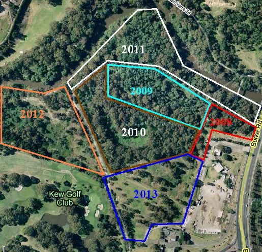
| Lack of information and direction at site entrances | Protect ecological values. Enhance visitor use of site through education and signage. |
Entrance A: Install welcome signs and interpretive display. Build picnic facilities. Continue revegetation to enhance aesthetics of area. Entrance B: Install additional signs. Give priority to weed control to optimise impact on casual visitors. Entrance C: Install additional signs. | Med | CoM |
| Lack of fauna data | Set up long term fauna monitoring with a database for future management decisions. | Collect historical data on fauna surveys for the last 10 years. Begin ongoing surveying. | Med | CoM DSE |
| Lack of native species habitat | Create fauna habitat to reduce fragmentation of Yarra River wildlife corridor. | Installation of nest boxes. Weed removal and revegetation. Retain some woody weeds. | High | CoM |
| Inappropriate use of site by visitors | Create spaces for recreational use within areas of low ecological significance. | Create a picnic and recreation area. Maintain some informal paths. Minimise any additional off-track activity. Install signs indicating behaviour standards. | Medium | CoM |
| SCIENTIFIC NAME | COMMON NAME |
| Acacia dealbata | Silver wattle |
| Alternanthera denticulata | Lesser joyweed |
| Amyema quandang | Grey mistletoe |
| Bursaria spinosa | Sweet bursaria |
| Carex appressa | Tall sedge |
| Coprosma quadrifida | Prickly currant-bush |
| Elatine gratioloides | Waterwort |
| Eleocharis acuta | Common spikerush |
| Eucalyptus camaldulensis | River red gum |
| Geranium sp. 5 | Geranium sp. |
| Goodenia ovata | Hop goodenia |
| Gynatrix pulchella | Hemp bush |
| Juncus amabilis | Gentle Juncus |
| Juncus subsecundus | Finger rush |
| Lepidium pseudohyssopifolium | Pepper-cress |
| Melaleuca ericifolia | Swamp paperbark |
| Melicytus dentatus | Tree violet |
| Microlaena stipoides | Weeping grass |
| Muellerina eucalyptoides | Creeping mistletoe |
| Ottelia ovalifolia | Swamp lily |
| Oxalis exilis/perennans | Soursob |
| Persicaria hydropiper | Water pepper |
| Persicaria lapathifolia | Pale knotweed |
| Persicaria prostrata | Creeping knotweed |
| Persicaria subsessilis | Bristly knotweed |
| Rapanea howittiana | Muttonwood |
| Triglochin procera | Water ribbons |
| Urtica incise | Scrub nettle |
| The following two species were possibly planted at the site: | |
| Acacia mearnsii | Black wattle |
| Acacia melanoxylon | Blackwood |
| SCIENTIFIC NAME | COMMON NAME |
| Acer negundo | Box elder |
| Araujia sericifera | Moth vine. Also known as white bladder-flower, cruel plant, kapok vine, milk vine, calico vine |
| Artemisia verlotiorum | Chinese wormwood |
| Aster subulatus | Bushy starwort |
| Atriplex prostrata | |
| Bromus catharticus | Prairie grass |
| Calystegia silvatica | Greater bindweed |
| Chrysanthemoides monilifera sbsp. rotundifolia | Bitou bush |
| Cirsium vulgare | Spear thistle |
| Conium maculatum | Hemlock |
| Crataegus monogyna | Hawthorn |
| Cynodon dactylon | Couch grass |
| Cyperus eragrostis | Umbrella sedge. Also known as drain flatsedge, umbrella grass, Victorian nutgrass |
| Dactylis glomerata | Cocksfoot |
| Ehrharta erecta | Panic veldt grass |
| Fallopia convolvulus | Black bindweed. Also known as climbing buckwheat, knot bindweed, wild buckwheat |
| Foeniculum vulgare | Fennel |
| Fumaria sp. | Fumaria |
| Galium aparine | Cleavers |
| Helminthotheca echioides | Ox-tongue |
| Ligustrum lucidum | Broad-leaved privet |
| Lonicera japonica | Japanese honeysuckle |
| Lycium ferocissimum | African boxthorn |
| Modiola caroliniana | Red-flowered mallow |
| Nassella neesiana | Chilean needle grass |
| Oxalis incarnate | Pale wood-sorrel |
| Phalaris aquatica | Phalaris |
| Phytolacca octandra | Inkweed |
| Pinus radiata | Radiata pine |
| Pittosporum undulatum | Sweet pittosporum |
| Plantago lanceolata | Ribwort, plantain, snake plantain |
| Plantago major | Greater plantain |
| Polygonum aviculare | Knotweed, wireweed, hogweed |
| Prunus cerasifera | Purple-leaved plum, cherry plum |
| Ranunculus repens | Creeping buttercup |
| Rorippa palustris | Yellow cress |
| Rubus anglocandicans | Blackberry |
| Rumex crispus | Curled dock |
| Rumex obtusifolius | Broad-leaf dock |
| Salix fragilis | Crack willow |
| Salpichroa origanifolia | Pampas lily-of-the-valley |
| Solanum americanum | Glossy nightshade |
| Solanum nigrum | Black nightshade |
| Solanum pseudocapsicum | Madeira winter cherry |
| Sonchus oleraceus | Common sowthistle |
| Tradescantia fluminensis | Trad. Also known as: wandering jew, creeping christian, wandering creeper, water spider wort |
| Ulex europaeus | Gorse |
| Verbena bonariensis | Purple-top verbena |
| Zantedeschia aethiopica | Arum lily |
| Scientific name | Common Name | Status in Melbourne | Status in Boorondara |
| Amyema quandang | Grey mistletoe | Vulnerable | |
| Carex appressa | Tall sedge | Endangered | |
| Elatine gratioloides | Waterwort | Rare or threatened | Vulnerable |
| Eleocharis acuta | Common spikerush | Endangered | |
| Geranium sp. | Geranium sp. | Endangered | |
| Goodenia ovata | Hop goodenia | Vulnerable | |
| Gynatrix pulchella | Hemp bush | Endangered | |
| Juncus subsecundus | Gentle juncus | Vulnerable | |
| Lepidium pseudohyssopifolium | Pepper-cress | Rare or threatened | Endangered |
| Ottelia ovalifolia | Swamp lilly | Rare or threatened | Extinct |
| Persicaria prostrata | Creeping knotweed | Rare or threatened | Vulnerable |
| Persicaria subsessilis | Bristly knotweed | Rare or threatened | Secure |
| Rapanea howittiana | Muttonwood | Rare or threatened | Critically Endangered |
| Urtica incisa | Scrub nettle | Rare or threatened | Vulnerable |
|
Butterflies: *Cabbage white Common brown Common grass-blue Fish: *Carp (1979) *Redfin (1979) Reptiles: Common blue-tongued lizard Tiger snake Common froglet (1994) +Victorian smooth Froglet +Southern bullfrog (1994) Striped marsh frog (1990) +Spotted marsh frog (1994) Southern brown tree frog Mammals: Common brushtail possum Common ringtail possum *Black rat *Red fox |
Birds: Pacific black duck Little black cormorant White-faced heron Eurasian coot (1990) *Spotted turtle-dove Common bronzewing Rainbow lorikeet Eastern rosella Superb fairy-wren Spotted pardalote White-browed scrubwren Brown thornbill Red wattlebird Bell miner Noisy miner White-plumed honeyeater Eastern spinebill Eastern yellow robin Grey shrike-thrush Magpie-lark Grey fantail Grey butcherbird Grey currawong Silvereye Bassian thrush (1997) *Common blackbird Kookaburra (2008) Australian magpie (2008) |
| Conservation Status | |||
| Common Name | Status in Melbourne | Status in Boroondara | Last Recorded |
| Platypus | Near Threatened | Endangered | 2005 |
| Bassian thrush | Near Threatened | Occasional visitor | 1997 |
| Victorian smooth froglet | Endangered | 2005 | |
| Southern bullfrog | Endangered | 1994 | |
| Striped marsh frog | Endangered | 1990 | |
| Spotted marsh frog | Endangered | 1994 | |
| Southern brown tree frog | Endangered | 2005 | |
| Common blue-tongued lizard | Endangered | 2005 | |
| Spotted pardalote | Endangered | 2005 | |
| Little black cormorant | Vulnerable | 2005 | |
| White-faced heron | Vulnerable | 2005 | |
| Eastern rosella | Vulnerable | 2005 | |
| Superb fairy-wren | Vulnerable | 2005 | |
| White-browed scrubwren | Vulnerable | 2005 | |
| Eastern spinebill | Vulnerable | 2005 | |
| Eastern yellow robin | Vulnerable | 2005 | |
| Grey shrike-thrush | Vulnerable | 2005 | |
| Grey fantail | Vulnerable | 2005 | |
| Common bronzewing | Occasional Visitor | 2005 | |
| Grey currawong | Occasional Visitor | 2005 | |